Monday, September 28, 2020

covid update

Here's the bottom of an interesting table. I sorted this by cases/100000 population and removed territories from the bottom of the list. It appears that the 'cold corners' are relatively good places to hang out, with the three uppermost New England states lowest and most of the PacNW nearly as low (except Idaho, which is having a surge right now). Conditions change quickly (just ask Idaho) but it's an interesting snapshot. 

One could add Alaska and Hawaii, but being adjacent only to Canada or water is a rather different case.


The two right-most columns are for deaths, total and per 100k. Those numbers are pretty low as well.

By the way - the 'warm corners' are suffering greatly. California tops the total-case list and suffers still from wildfires and smoke. Florida is in the top-five for cases as well, plus rising sea levels make things a misery in other ways at high tides.


a wet week

 The past seven days provided us with about 3½ inches of rain, so September has again beat the 30-year average by quite a bit. Sep/Oct have been the most consistently wet months since we arrived here, a definite change from my memories of Septembers in Portland. Amazing what an hour's drive (or a 30-minute crow flight) can do to conditions, with the Columbia gorge reduced in influence. The 'water year' shown here begins in July, so the long-time averages are 189% for September and 180% for October. September has doubled its average here three times, but the wettest-ever month was October 2016 at 366% - over twenty inches.


Note that August, November and May are the least efficient months on our hill-top, with fairly consistent underperformance relative to the 1981-2010 period. November is supposed to be our wettest month of the twelve, with 10.84" expected; it's reached that twice but failed badly twice; last year left a hole that needed a huge January managed to fill (over 18" total, second-wettest month on the list!). 

Averages are one thing, standard deviations quite another!


Friday, September 18, 2020

Rain? postscript

 It took a few days, but oh it came to us today /Friday. Two hours of powerful thunder in several directions, 1.08 inches of rain - and far better air quality than we'd seen since Labor Day. Definitely worth waiting for! 


Saturday, September 12, 2020

rain? Yes please

As summer wanes and the jet stream reawakens, the dry days of our local summer begin to break down. Given our crazy smoke and fires of the past ten days, we'll gladly take the change! The map here shows the next week could bring us over an inch of rainfall, which along with the onshore flow will take the wildfires down several notches as they are forced back to areas that have already burned the available combustibles. The rain doesn't get much past the Cascades, and the jet stream will not  be visiting California soon - so for now only WA/OR will get the benefits.

Once the danger has passed I can finally cook on the grille outside, maybe even mow the dandelions!

Looks like our area gets a good soaking - until you see what TS/Hurricane Sally has in store for Louisana..

Friday, September 11, 2020

well now what's this?

 A happy surprise or two. 

The GX8 has arrived - and it isn't black. I expected a black in EX condition; this seems the right evaluation but a very shiny silvery shade of black! It's OK though, as I prefer this two-tone look, especially when the silver 20mm comes out to play; if they had labeled things right I'd have selected this copy anyway!

Here it sits with the new-to-itself Pentax 40mm XS lens. I seem to have sent off my relatively smart aperture-control adapter, but a hard rubber stop fits in the adapter and holds it at a preset opening (probably f/4ish). I've ordered another with the ap-control ring for sanity's sake.

With the 12-60mm lens it's a weather-compatible setup; with primes (including the 40) we have 8-20-40-60mm.. an adapted 90mm macro and 150mm*. That's a nice spacing.

* A Pentax 150/3.5 was just appended - did not expect that bid to hold up.

Tuesday, September 8, 2020

firefights


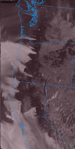
A cool blast of high pressure fell down the Rockies this week, and a huge pressure gradient sent winds south and west. The dry season is near its max, and this caught every smoldering fire and blasted them into inferno mode. The NW has joined California, which has already been mired in deep smoke since the weekend.

The satellite image here shows the Cascade smoke plumes flowing west and probably making the hot-weather forecast a bit more challenging with the obscured sunlight. A faint plume off Mt. St.Helens is actually ash being pushed west by those strong winds! Other fires in central Washington are less clear since the winds have relaxed a bit up there - but those fires have also make large jumps into new territory. Large-scale alerts and watches are out, as any spark or smolder could take over in a hurry right now.

The hottest weather is coming in the next couple of days, but the wind should relax a bit; by next weekend the west wind will be in charge on this side, bring cooler air from the ocean and sending the smoke to other areas.


Update 9/10 - the hottest day of the forecast has become the thickest for smoke, so 90° may be out of reach. I'm OK with that, but oh the smoke.. from Olympia to San Diego plus several inland locations. Not a great day to breathe - but I'll do it anyway.


Saturday, September 5, 2020

why the GX8, exactly? And why Now??

The GX8 is now my primary camera. 

My track record makes clear that I don't make good body choices* - yet here I sit typing bold statements like the one above.  It sure looks confident - especially for a camera that won't arrive for another week. One would think I should touch it first, perhaps? Yeah, that's not easy to do any more - especially with a camera no longer in production.

The GX8 has been around for five years, and in that time I've tried em5/10/10.ii and g7/8/gx85 bodies - and a YI M1. Yet I didn't try this one, and at several forks in the road I was sure that decision made sense.