Showing posts with label wx. Show all posts

Friday, August 15, 2025

August?

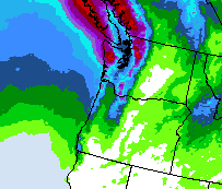
 Sure doesn't look like an August forecast. 

And this isn't a forecast five days out; this is tomorrow


Our average August has 0.99" in the whole month - and we had .40" a week ago! This chart adds an additional 1.39 inches, and another .15 or so arrives after 6am Saturday. So we might double the typical August - assuming it does not rain in the second half of the month.

It's a good month to double the average as a) this is the 2nd driest month of the year and b) July, the driest on average, had Zero rain this year. So our summer average should square up nicely with this nice surprise drenching. Hopefully it will do a number on several fires in the region, especially on Vancouver Island and the Olympic peninsula. East of the mountains should get some of this also, but it always comes with wind that can whip up the fires as much as dampening them. Fingers crossed!

Update - the storm has carried itself further north so far, with just .15" during the first part of Saturday. The leading edge of the cold front is finally reaching us at 3PM, so the relatively dry spell is over now!

Update 2: 1.64" total for Thu-Sat, and 2.04"  for August. The 30yr normal is 0.99".

Update #2: 2.04" total for the month. The last four years average to 1.0".. therefore normal!


Wednesday, July 30, 2025

dry season!

 August 2022, and now July 2025. The only two months at our hill-top home with zero recorded precipitation. Since the average in those two months is less than an inch, it doesn't have much impact on the annual values. Clearly it's still pretty rare! My records go back to 2014, so twice in 11 years is rare.

August may have a few showers by the 5th - we'll see about that? 

Update - oops, the forecast dried out. For one hour on the morning of 8/7 we have a 30% chance of .. something drizzly, I presume. Here's the next 7 days of moisture as of July 30th.


Thursday, May 29, 2025

springy!

 We'll take it!


This is an ideal start to June - morning clouds, afternoon sunshine, max temps in the mid-70s. Since I cannot lift heavy objects yet post-surgery, the air conditioner can wait another 10 days. Tomorrow is the warmest in the forecast, so just one day of discomfort.

Nice.


Update - the Wx Underground forecast graphic is for valley-floor locations, which is always ~4 degrees off from our hill-top site. It's generally warmer in summer with thicker atmosphere, but colder in winter thanks to cold-air seepage. We reached 80° Friday up here, and NWS temperatures near 750' show mid-upper 60s next week. 

Nearly as nice!

Tuesday, January 28, 2025

the Snow Month looms

 Well, it's almost February - our historically snowiest month on the hill-top. January has mostly been dry, cold and clear, with about 1/3 of normal precipitation. The pattern change is right on schedule!

I have surgery scheduled for mid-March based on our February snow history; looks like it was a good idea.

It's still about a week away, so no doubt the numbers will dance a while before the event unfolds.


Update: a respectable forecast! We had 2" in the 2nd, melted half of it then added two more! Quiet on the 4th but more showers on the 5th. No big dump (which was not predicted) and it was gone below 400'.

Friday, December 20, 2024

Christmas in liquid form


Our hill-top forecast for Christmas looks mighty wet. It's been this way for a few days now, so it's getting harder to ignore. Christmas Eve isn't too bad, but if we head north to the in-laws neighborhood we have no decent day for the return trip. Rivers would be high and possibly dropping debris into the Puget Sound, possibly affecting ferry service. That would force us into Seattle traffic.. seldom pleasant even in a light rain, and forecasts there are 1/2 inch each day. Not ideal.

Cliff Mass blog is on it as well: 

https://cliffmass.blogspot.com/2024/12/an-intense-christmas-atmospheric-river.html


update - storms were not as extreme for the most part, and my Saturday drive was into a cloud bank but not miserable. From 12/24-31 we received a total of 4.6" on the hill-top, which gave us a 125% of normal for December. The wettest days were Thu and Fri with just over an inch each.

Wednesday, November 6, 2024

Damp season


The storms came in hard and fast in late Oct, pushing us from 41% to 95% of normal in the last week. We're taking a break for a few days, but the days soon after will compensate! Our 7-day total looks to be about four inches. 

Wow. 

Monday, September 30, 2024

water year wrap-up

 And so much for water year 2024!


The year ended right at 56 inches of precipitation - within two inches of our 30-year average. No massively above-normal months, and July and August were typically dry. It was a damp year compared to 2023 which was our driest year at this location (43.3"). One of our dampest days was on June 2nd; we had higher totals once or twice but that was from rain after snowfall has piled atop the gage from the day before. 

Temperatures were not hugely out of alignment, and August in particular was not a hot month. We managed some 90° days in July but not a single one in August! We had a few periods of decently gusty winds but thankfully a quiet year for smoke; what we had remained high overhead. The 'chance of thunderstorms' for our location was a year-long bust; I can't recall more than one thunder-clap the entire year, while others sat underneath several exciting events.

This past week I saw how desiccated Mt. Hood has become in late summer. My views were not through clearest skies, but I spent most of my life looking at that mountain in all seasons - and the glaciers have definitely become less visible. The Reid glacier faces Portland directly, and I recall hiking above Ramona Falls to high meadows directly in front of the headwall; it would be troubling to be that close and see the retreat from my 1980 photos.

As to 2025.. the El Niño pattern has fallen into the zone of indifference between it and La Niña. That's often the wetter and more volatile signal around here. Time will reveal how the patterns play out.

Thursday, July 25, 2024

smoke season arrives

The wildfires are in full summer bloom in the western USA. Another Oregon Star Party has been cancelled: the USFS has too much going on to allow for a group of 500 to show up for a week. The 2020s have not been kind, as two Covid cancellations and major road work took out three of the first four this decade.

Well north of the brown smoke shown here, the township of Jasper AB was substantially consumed by a fire yesterday. Over 25000 people were safely evacuated from town and park, but emergency crews had no chance against the swirling winds and walls of flame.

Tough times. 


Thursday, July 4, 2024

firecracker weather!


Typically around here we begin summer on July 5-7th, whenever the last Pacific storm visits with enough strength to keep us in the upper 60s. We are starting a day early this year, and we're trying for 100° this weekend. Just 80 today, it appears - but we may not see another day in the 80s until a week from now. Thankfully the coastal cities and beaches only suffer two days of heat before the onshore flow is sufficient to bring back the 70s - so that's a daytime destination we are considering strongly!

Wrap up: well, that was unpleasant. Portland reached 100° and Salem was a few degrees warmer. We didn't visit the beach, but A/C and mist on the deck were fully employed.


Wed max was 16° cooler after a 10° drop in the morning. A decent west wind broke another 15-foot branch from a tree in our yard.. that's about the fourth of similar size to come down this year!


Monday, May 27, 2024

rose festival weather

 Here it comes again: the early-June shower pattern for areas around Portland.


Since the Rose Festival carnival rides are always on the lawn by the Willamette, it's a good bet that they will become muddy in the next two weeks. Portland itself is only in the half-inch zone at this point, so nearly not mud. Living an hour north is big though, as we are forecast to see over an inch by the 4th of June. Much of that comes on the 1st/2nd as of now, so several days of pattern mutations are still available.

I'm trying to whack down some blackberries before damp times return, and the new 62v whacker is doing nicely with its bonus torque over the 18v model. 
Don't make me get out the chainsaw!!


Another yard task is to burn the debris that has accumulated near our driveway over the past two+ years. Some showers are expected tomorrow, so that would be ideal as long as the winds are not active. Hopefully by the weekend the yard will be looking far better than it has in a long spell!


Tuesday, April 23, 2024

another dry month with a wet finish

  -- coming soon!

We've had less than 30% of our April normal, and a week to make up for it. A totally dry week ends today: tomorrow should have a bit after dark, but Thursday will bring close to an inch. Wow! We'd need 3½" to catch up, and that is not expected to happen. 

This hurts more because I now have my tool prepared for halting the blackberry invasion. I looked up how to swap the brush blade onto our string trimmer and how to actually start the beast. Tomorrow is a travel / medical day, so we'll be back with a few short hours to work before darkness arrives and the rain begins. Friday should be less wet but showers continue for several more days. 

Guess I just need to embrace the dampness and get cracking! :^)

One piece of good news though: the riding mower is functioning again! I replaced a few parts, zip-tied the front end into a reasonable approximation of its original orientation, and finally found the culprit: the fuse wiring had come loose from part of its harness and was dangling uselessly. Now to purge the ancient gas and oil from it, and forget the last two summers were such a challenge..


Friday, March 1, 2024

welcome to March!


The cold, somewhat messy March lion has arrived!

After a five-day rally to make February into an above-average month (105%), March cones in chilly. The 7-day forecast is for about 1½" of wet snowflakes; we have a solid trace on our deck and in our grass as I type, and a snowy mix is falling.

It seems that our groundhog lied. Break out the pitchforks and torches!!


Update. The early forecast was for perhaps 2" total snowfall, at best an inch each night and gone the next afternoon. Reality was more exuberant: over 9" on the ground at maximum, and today (3/8) still ,shows three inches on deck and driveway! 
Exuberant indeed. 

Tuesday, February 27, 2024

late-month rally

 With five days to go, February was 39% of normal for precipitation. That's asking a lot of five days.

And then it began to rain.

As of this morning we're at 60% - and forecasts add about 2½" more (thanks to having a 29th  day this year!). If this pans out we'll have (a) two really wet days, and (b) 105% of normal!

Let's find out..

Update, 28 Feb. Now just 0.8" short of average (87%) -- and the cold front is making its appearance at the coast! We never used to have such detail, but the somewhat recent addition of a radar near Aberdeen really improved the up-wind view.


The next seven days are quite damp, showing that the first few days of March 
will come in like a lion - and not just for us!!


Friday, February 16, 2024

California takes a turn

February has been less damp than recent months, as the rapidly weakening el Niño sends moisture south of us for a while. We're around 30% of normal halfway through the month.

Our coming week has perhaps an inch of rain, but several recent forecasts have been too enthusiastic about amounts. We even flirted with a snow forecast this week, but in the end the cold vs. moist boundary ended up closer to Olympia. Oh look; our forecast now has a 900-foot snow level tonight..

Next fall looks like we're back to La Niña - but many climate folks are now wondering if enough global change has been wrought to break our conditioned expectations. It's always been clear how things settle out in Niña and Niño years.. but last year's California weather was not typical at all. Lake Manly (aka Badwater / Death Valley) formed after Hurricane Hilary and it's been replenished by recent storms; Tulare Lake reformed and hasn't vanished either. Perhaps we need to watch a few more cycles before throwing out all our experience; we'll find out!

Monday, January 22, 2024

Back to normal

 Version 1: temperature is now above 45° and snow is down to tiny patches. A half inch of rain has fallen today so it may all be gone by sunrise. The melt plus rain was nearly 2"!

Version 2: with a week to go, January should end up at least an inch above normal (OK, 2½" above as of the 27th!). That means our water deficit since October will be a surplus.. for a little while, at least. 


Wednesday, January 3, 2024

a first glance at winter

Our moisture has come from the south so far this rainy season, so ski resorts and winter-focused events have not fared well. Many storms near California will do that, and el Niño often leaves its mark to our south, pushing warmer air our way to limit snowpack. It does not make us immune to winter weather though!

Today's Wx-Underground forecasts have turned toward snow about a week from now, which is surprising. Many models have made this shift, however; shown here is the well-regarded European model's view on Friday morning 1/12. This is pretty much the classic pattern for white weather down low, with cold air just onshore and marine moisture willing to be pulled in just to its south!

This could change in six hours with the next model runs, and in the course of a week's modeling the timing and location will likely revise a few more times. Still, it's notable. 

We'll be watching..


7Jan update: the forecast has twisted several times as to depth of cold air and accumulation, but the 12-13th remains white at our 750' elevation. Values have varied from 3½ to 12 inches from run to run!

7-16 recap?

Curiously enough, winter weather began abruptly on Tuesday the 9th, with over 6" on the ground on Tuesday morning. It was a strong suspicion but nothing more on Monday night as we drove back from Anacortes in downpours.

That settled down to 4" by Friday 1/12, when we topped off the crunchy old snow with 4" of fresh true powder. The arctic front dropped us to 16° at night through Monday the 15th. Today the cold air was overrun by a front coming from the SW; only a pinch of fz/rain has fallen so far, and the forecast has us above freezing by sunrise. It will take a day or two for the snow to vamish, but the wild times will return to normal in 36 hours or so.

7-17 - It was a good try, but it took until 10am to reach freezing, and 2pm to reach 35. 

Time to start shoveling the driveway!


Friday, December 8, 2023

yet another storm.. then some peace?


We've had three or four atmospheric rivers in the first week of December, putting us at 2/3 of normal monthly rainfall already. A quiet day today, then another punch coming for Saturday. 


Hints of a few days of quieter weather are showing on the models. Not entirely dry perhaps, but fewer 2-inch hits of tropical temperatures and rainfall. We'll see how it pans out. The forecast for the first week of December was 5-6 inches, and it was correct at this location - 5.65" for Dec 1-6, plus 1/2" on the 7th and 1/3" on Nov 30th.


Wednesday, November 22, 2023

another dry-ish month. And then..

We've reached the 22nd and the forecast is for a dry week. As we sit at 79% right now, it means another sub-standard month will go in the books without a large shift in the forecast.

Since November through January are the wettest of months here, being around 80% is a decent amount, just over seven inches - but last winter all three were drier than average and that's a bad habit to get into!

El Niño is upon us, big time this year, which often means weaker storms for us as more energy dives south to California. It often strikes early in the calendar year, so more storms in December would be a very good thing. 

- - - - - - - - - - - - - - - - - - - - - - - - - 

Update - maybe 1/4" on the 30th, but probably closer to 0.10". And then the floodgates open - as the models seem to do quite often at the turn of a month. I'll footnote this for certain to see how close we come to it! At our location we'll call it 5" - but the neighborhood is 4-9"  and boundaries are rather vague at this scale! 

This graphic runs through 4PM on the 4th, so nearly everything here is December 1-4.


11/30 update - wx. underground 1-6 Dec. Six-ish in the forecast. Today is at .21" with a pinch more possible around midnight.


Monday, October 30, 2023

skeptical

 We shall see how November starts - but given that most October forecasts came up short, this looks pretty .. enthusiastic.


Here's the news 7-day map. It also appears to be convinced.


Update - Nov 1-7 total ended up at 4.8", a bit lower than most forecasts but not a bust for a wide-area map that put us in the 5-7 inch range. Monday's rain was from the 3rd atmospheric river of the bunch and was pegged as the weakest, but location is everything with such streams of moisture. We had 1½" for the day and its the 4th day since mid-October to be over 0.85". 

We're over 50% for November after the first seven days! The upcoming week may only add an inch or so, putting us at six inches at mid-month. Time will tell, as it so often does..


Sunday, October 22, 2023

Updates, on many subjects

 October has been ..active. Here's a summary of the Story so far:

  • My health is pretty decent after surgery, but it took several days to be sure that the gut aches were gone since the surgery hurt the same areas of my gut! It seems that all went fine, best evidence being my late-evening discharge. I'll learn more from the doctors in early November.
  • Weather has been underperforming for the month, as every large forecast has dried out upon reaching us. Split flow is common with el Niño patterns, as strong fronts are spun up to our north and the southern end does a soft landing near the California border. Maybe they will consolidate more in coming weeks, but October is looking like a 50-60% kind of month.
  • Camera gear was a surprise, as the new acquisitions of recent months all slipped through my willing fingers. I'm back to an eM1 and K-s2 - and am convinced that these are the best fits and image quality that I need. I'm a big fan of 4:3 images, more so than 3:2; thankfully Pentax crops to square and 4:3 very easily after capture.

So things are going decently well, other than the somewhat dry weather. More coming tomorrow though!