Our master shower has been running cold lately. It occurred to me that our other shower would do fine.
I was wrong. The push-pull hot-cold part didn't provide any water of any temperature.
While looking into the magic cartridge that controls such taps I leaned that a lack of heat or cold is a possible sign of failure. How nice: they both need replacing!
I tried to visualize what the correct part would be on the local store's parts shelf, but clearly the best option was to bring a part with me - both parts, in case they differed.
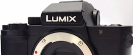
The main bath cartridge didn't want to yield at first, but the master tap cartridge let go without trouble. I went back and did the same on the other and finally extracted a much smaller and incomplete part :√(
 |
| Exhibit A: 1½ cartridges |
Off to the repair store again - this time with a samples! As I'd suspected the Moen 1200 was the right choice, and the specialist agreed that they were probably both the same despite what I carried. Once home I used a big drill bit and some pliers to yank out the remaining cartridge bits. Everything went smoothly after that!
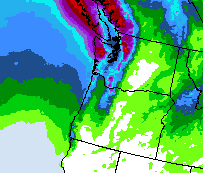
- Until I visited the water heater, where one more task waited me. While putting a light amount of pressure on the outlet post on top, the one task became two:
 |
| Exhibit B: outlet hose failure |
Off again to the store, and I decided to grab two hoses.
I'm tired of digging into this closet to change out fittings!! I needed threads on one side and a slip-on clamp for the other, and it went together pretty well. All done?
Oh no - not yet. I'd totally forgotten the original reason for visiting the water heater, and it took full advantage of my forgetfulness when I restored the water pressure. All the hose work I performed had caused the suspect part to fail - so off with the water supply, again.
The problem was another fitting I had put in a year ago. The cold-water pipe had failed lower down, but a slip-on clamp solved the problem; parts for the hot side were in hand but it hadn't been updated. I knew it was a matter of time.. and that time had now come. The hard way.
After inspection I decided this last problem was in fact two, or perhaps more: two suspicious connectors (one showing it had failed, the other waiting its turn) plus poor routing of my new hoses from the water heater. One final store visit brought home a longer pipe, another slip-clamp connector and the right tools (locking pliers and pipe cutter) to see things done right.
I rerouted the heater hoses, shortened them a bit and replaced the old tubing and two connectors with a solid piece. I also marked the pipes to ensure the slip clamps were fully inserted, as a few drops along one hose weren't reassuring.
So my two-plus days of shopping drilling cutting and yanking are done, and everything is currently holding! Both showers have hot water again, toilets and dishwasher are functioning, and a bunch of wet towels are off the ground and in the laundry.
Oof.
Later - wow that was a hot shower! Perhaps the heater can be turned down a notch..
Also later - I found my pipe-cutting tool right after returning home with a new one. I look forward to all my missing lock pliers coming out of their hiding places soon!


.png)


