 A cool blast of high pressure fell down the Rockies this week, and a huge pressure gradient sent winds south and west. The dry season is near its max, and this caught every smoldering fire and blasted them into inferno mode. The NW has joined California, which has already been mired in deep smoke since the weekend.
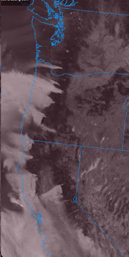
The satellite image here shows the Cascade smoke plumes flowing west and probably making the hot-weather forecast a bit more challenging with the obscured sunlight. A faint plume off Mt. St.Helens is actually ash being pushed west by those strong winds! Other fires in central Washington are less clear since the winds have relaxed a bit up there - but those fires have also make large jumps into new territory. Large-scale alerts and watches are out, as any spark or smolder could take over in a hurry right now.
The hottest weather is coming in the next couple of days, but the wind should relax a bit; by next weekend the west wind will be in charge on this side, bring cooler air from the ocean and sending the smoke to other areas.
Update 9/10 - the hottest day of the forecast has become the thickest for smoke, so 90° may be out of reach. I'm OK with that, but oh the smoke.. from Olympia to San Diego plus several inland locations. Not a great day to breathe - but I'll do it anyway.

No comments:
Post a Comment